Study Area Map Generator: A Web-Based Shiny Application for Generating Country-Level Study Area Maps for Scientific Publications
The Study Area Map Generator, developed by Dr. César Iván Álvarez (University of Augsburg), Dr. Juan Gabriel Mollocana-Lara (Universidad Politécnica Salesiana, Ecuador), Dr. Izar Sinde-González (Universidad Politécnica de Madrid, Spain), and Prof. Ana Cláudia Teodoro (University of Porto, Portugal), is a freely accessible web application that greatly simplifies the creation of high-quality study area maps for scientific publications.
A digital tool for reproducible map creation
The Study Area Map Generator is a freely accessible, web-based application designed to simplify the creation of high-quality study area maps for scientific publications, theses, and policy reports. Developed by Dr. César Iván Álvarez (University of Augsburg, Germany), Dr. Juan Gabriel Mollocana-Lara (Universidad Politécnica Salesiana, Ecuador), Dr. Izar Sinde-González (Universidad Politécnica de Madrid, Spain), and Prof. Ana Cláudia Teodoro (University of Porto, Portugal), the tool bridges the gap between advanced cartographic visualization and the growing demand for reproducible, open-access research workflows.

Technical implementation of the tool
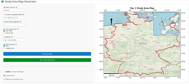
Built using Shiny for Python, the application integrates modern open-source geospatial libraries — including GeoPandas, Cartopy, and Matplotlib — to generate publication-ready country- or city-level maps directly in the browser, with no need for GIS software installation or technical expertise. Users can choose any country or city through a simple interface, add a custom title, select basemaps (OpenStreetMap or Google Hybrid), adjust the zoom radius, and include inset maps showing the global context of their area of interest. All maps are exported automatically in high-resolution (300 DPI PNG), meeting the technical requirements of scientific journals.
A usability survey conducted among 92 participants from over 20 countries — including researchers, students, and professionals with varying levels of GIS experience — confirmed the tool’s high usability, clarity, and usefulness. Over 90% of respondents indicated that they would recommend the application to others. Statistical analyses revealed no significant differences in satisfaction or perceived usefulness between expert and non-expert users, highlighting the platform’s accessibility and intuitive design.
- Phone: +49 (0) 821 598 4865
Global use and open development
The Study Area Map Generator has already been adopted in multiple academic and educational contexts across Latin America, Africa, and Europe, supporting the preparation of journal articles, graduate theses, and training workshops in geospatial sciences. It has proven particularly valuable in low-resource settings, where access to commercial GIS software is limited, and it aligns closely with open science and FAIR data principles (Findable, Accessible, Interoperable, and Reusable).
The tool’s open-source code is available on
GitHub, allowing researchers and institutions to modify and extend it—for example, by adding subnational boundaries, thematic overlays (such as land cover or population density), or multilingual interfaces. Future updates will enhance export options, include improved scale bars and inset alignment, and introduce a “high-resolution mode” for more detailed cartographic outputs.
Access the application online here.
Alvarez, C.I.; Mollocana-Lara, J.G.; Sinde-González, I.; Teodoro, A.C. Study Area Map Generator: A Web-Based Shiny Application for Generating Country-Level Study Area Maps for Scientific Publications. ISPRS Int. J. Geo-Inf. 2025, 14, 387.
